
Pulse en una miniatura para ir a Google Books.
|
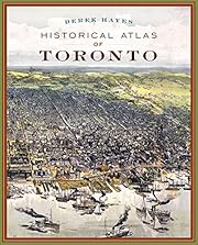
Cargando... Historical Atlas of Torontopor Derek Hayes
   Ninguno Actualmente no hay Conversaciones sobre este libro. sin reseñas | añadir una reseña
In just two centuries, Toronto has grown from a far-flung outpost of the British Empire to a world-class city, the largest in Canada. This book is the first to illustrate Toronto's history through contemporary maps, drawn at the time to record, promote or illustrate major events. Collected together for the first time, these beautiful, revelatory documents add up to a fascinating visual history of the city's development. The book covers all of today's Greater Toronto Area, from Mississauga in the west to Oshawa in the east. No se han encontrado descripciones de biblioteca. |
Debates activosNingunoCubiertas populares 
 Google Books — Cargando... Google Books — Cargando...GénerosSistema Decimal Melvil (DDC)911.713541History and Geography Geography and Travel Historical geography North America Canada OntarioClasificación de la Biblioteca del CongresoValoraciónPromedio: (4.14) (4.14)
¿Eres tú?Conviértete en un Autor de LibraryThing. |
|||||||||||||||||||||||||||||||||||||||||||||||||||||||||||||||||||||||||||||||||||||||||||||||||||||||||||||||||||||||


New to the city myself (and, admittedly, rather a map geek too), I have learned a great deal just by browsing this excellent book. Names, geographical features, road layouts make much more sense to me now that I learned how they came to be. For example, I realized that a street in my neighborhood called "Indian Road" is so named because it follows an ancient path used by the Mississauga Nation long before the first settlers came to the shores of Lake Ontario. As the settlement, then the city grew, it spread its network of roads around this ancient path, connecting modern urban design with age-old wisdom. It's easy to forget how much a city grows organically. Studying historical maps is a great way to bring that fact back to life. (